BY BILL SIMEONE
Traditionally, authority over Ahtna lands and resources rested with chiefs who held inherited titles. Each title was attached to a particular winter village and based on the name of that village and the term denen, or ghaxen. For example, the chief of Tyone Lake was known as Sałtigi Ghaxen, or “Person of Sałtigi’.”

There were at least 17 inherited titles: eight in Lower Ahtna territory (Copper Center south to Chitina), six in Central Ahtna territory (Copper Center to Gakona-Chistochina), one in Western Ahtna territory (Tazlina Lake to Cantwell) and two in Upper Ahtna territory (Chistochina to Mentasta).
This arrangement suggests that the titles were associated with copper sources, salmon fishing sites, and major trails leading in and out of Ahtna territory. The point is that leaders with inherited titles were closely associated with the land and controlled the allocation of important resources within their various territories.
When the United States purchased Alaska in 1867, it acquired title to all land not owned by individuals. The treaty provided that tribes, such as the Ahtna, would be subject to laws and regulations that the U.S. might later adopt with respect to aboriginal land rights, but for the time being the question of whether the Ahtna had aboriginal title was left unanswered.
Under U.S. law, aboriginal title is based on “use and occupancy” and the government can either give Native people full title to land or extinguish aboriginal title with or without monetary compensation. U.S. government policy has been to grant title only to lands that tribes actually occupy (i.e. live on), and to extinguish the aboriginal title to the remainder of the lands by placing them in the public domain.
In 1884 Congress passed the Organic Act, one of several laws purported to protect Native land. It was based on the assumption that individual Native people were entitled to land they used or occupied but that Alaska Native tribes could not prove aboriginal claims to larger tracts of tribal property, such as tribes in the Lower 48 states.
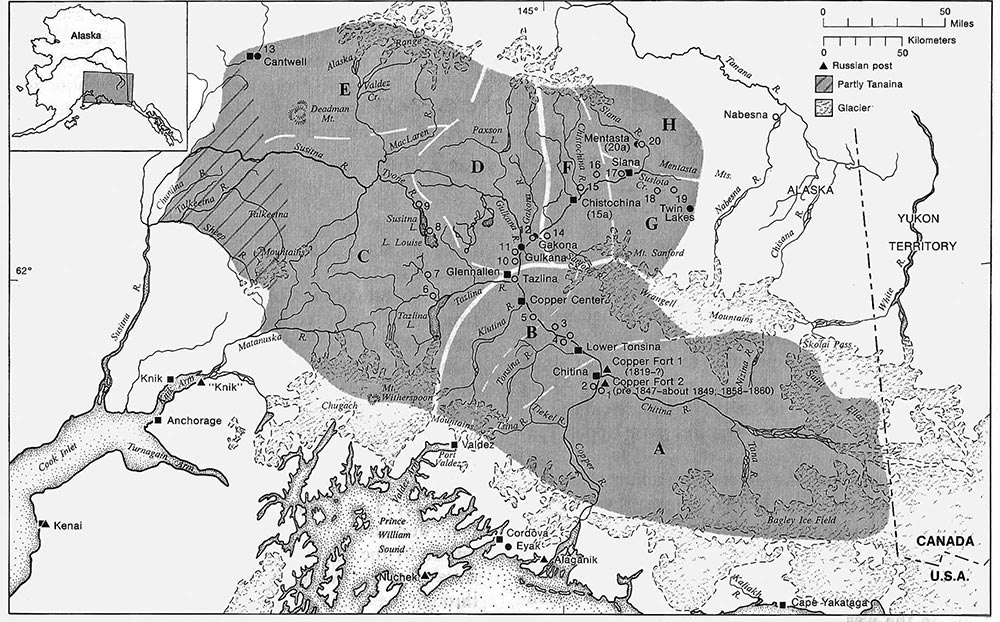
At the time of the Alaska purchase, traditional Ahtna territory encompassed the entire upper Copper and upper Susitna river basins. Lt. Henry Allen, the first non-Native to explore the Copper River, estimated Ahtna territory at 25,000 square miles. A recent map, published by the Smithsonian in 1981, showed the boundaries of the traditional land base extending from Cantwell in the west to the U.S./Canada boundary in the east, approximately 41,000 square miles.
Attachment to the homeland is expressed in Ahtna language and culture. There are over 2,000 Ahtna placenames. Important villages claim a prominent hill or riverbank that represents the people’s attachment to the land and the strength of their leaders. Certain men, referred to as nen’k’e hwdenae’ – or “on the land person” – embodied this connection to the land.
Elder Annie Ewan described these men as “Big chief, like you call somebody live in a place for years. Like somebody born there and died in there in that place, is more important. A rich man.”
Four major subdivisions (in bold) of Ahtna based on language and geography. There are 8 different bands – labeled with capital letters.
Lower Ahtna
A) Chitina –Taral Band
B) Tonsina-Klutina Band
Western Ahtna
C) Tyone-Mendeltna Band
E) Cantwell-Denali Band
Middle Ahtna
D) Gulkana-Gakona Band
Upper Ahtna
F) Sanford River-Chistochina Band
G) Slana Batzulnetas Band
H) Mentasta Band
Source: Smithsonian Handbook of North American Indians, Volume 6 Subarctic
Nineteenth century bands with 19th and 20th century villages (chief’s quarters) and dates of occupation when known.
You can reach Bill Simeone at wesimeone2@gmail.com with comments and suggestions.
