
By Katie Finnesand, AI Land Department staff
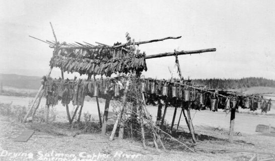
The people of the lower Ahtna region, including Wood Canyon near Chitina, have lived on the rich Copper River salmon supply for millennia. The steep canyon walls of the Northern Chugach range act as a bottleneck, crowding fish into narrow passages for a concentrated catch. Historically, people used spruce root baskets attached to long poles to dipnet fish from wooden platforms that extended over the swift water. Fish were processed in such quantity as to sustain numerous villages through the winters.
In the early 20th century, the Copper River and Northwestern Railway interrupted the lives of our ancestors as an influx of outside interests entered Ahtna country by way of the Cordova-Chitina route. The mountainous terrain left little room for alternative routes, and the Kennecott-bound railroad cut through several Native villages, forcing occupants to move from their time-honored homes. In later years, the contentious Copper River Highway (nicknamed the “Hickel Highway”) was constructed over much of the original railbed in two sections – from Chitina to the Tiekel River and from Cordova to the Allen River. Construction fizzled and the two segments were never joined, but the Copper River Highway served as a popular destination for many. Ahtna families who had continued to use their ancestral homes as seasonal fish camps in the Chitina area soon gave them up for good due to the unprecedented arrival of fishermen and recreationists.
Today we are seeing the northern Copper River Highway segment reopened for the first time in a decade or more. The Alaska Department of Transportation & Public Facilities (ADOT&PF) cleared semi-obstructive landslides in late Fall 2020, which only the most committed and diehard fisherman had navigated in the preceding years when regular maintenance had not occurred. The Chitina Joint Task Force, a dedicated group representing Chitina Traditional Indian Village Council, Chitina Native Corporation and Ahtna, Incorporated, is collaborating to implement an area management plan that will protect vulnerable cultural resources within or in proximity to the public right-of-way. The anticipated increase this Spring of fishermen and recreationists along this route (locally known as the O’Brien Creek trail) has the potential to threaten indigenous village sites, graves, house pits and other resources. The Joint Task Force hopes to engage the ADOT&PF in its efforts before the 2021 state fishery opening.
Immediate protections on Ahtna, Inc. land include the construction of fences and/or the placement of rock barricades around culturally sensitive areas, the designation of permissible public river access points, a vigorous public outreach program, and a tentative AI Natural Resource Technician position based in the Chitina area.